The plane approaches Tierra del Fuego. Earlier while still over the open
Atlantic, I had a look out of the window and marveled at the wind-whipped surface,
frightening the observer even from 30,000 ft up. Now, as we cross the north-east coast, I
see the wide tidal zone and a silvery river that winds 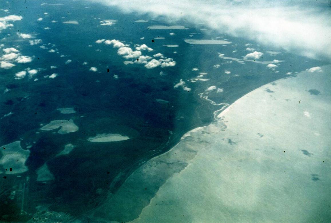 out of the brown interior
towards the coast. The town of Rio Grande (at the bottom left corner in the photo on the
left) looks small and insignificant in this large landscape and my attention is drawn to
the straight lines of the roads and the occasional patch of dark green forest. That's
where I will be traveling.
out of the brown interior
towards the coast. The town of Rio Grande (at the bottom left corner in the photo on the
left) looks small and insignificant in this large landscape and my attention is drawn to
the straight lines of the roads and the occasional patch of dark green forest. That's
where I will be traveling.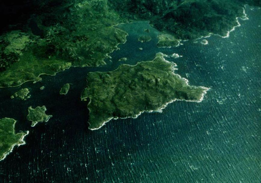
Then clouds obscure the view. Not long later, the plane banks to the east and a tear in the clouds reveals the Beagle Channel below and Isla Navarino across. The island looks wild and wet, and a bit further east, there is even snow. The plane banks again and doubles back, on approach to the airport of Ushuaia. It is hard to stay clear of politics: the photo of Ushuaia's runway comes from a promotional website. In its label is the reference to the Malvinas or Falklands, islands a few hundred kilometres to the east. When I check later the history, I find that there have been conflicts over these islands since 1832.
The 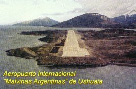 wind shakes the plane as we streak down
the runway, and it's obvious that it has rained just minutes ago. Once in the terminal, I
join the throng of tourists that hover in the baggage area and try to figure out my next
steps: find a place to sleep that won't cost an arm and a leg and hire a cab that is able
to take me and my huge bicycle box to the town. This is Argentina, and I speak no Spanish,
yet. The first panic sets in when my panniers show up on the conveyor belt but the bike is
nowhere to be seen. I check with the office of Aerolinas Argentina and find it had been
sent ahead yesterday. Now, it is hidden behind a pile of other luggage. Relieved, I turn
to the next challenge: finding a place where to sleep. The lady at the tourist information
booth is pretty helpful and books me into a dentist's "hospedaje": in this case,
the basement of the large and new house was converted into a dormitory to make some cash.
The address is "Provincia Grande 625" and the phone number is (0901) 22730, in
case you are looking for a place. The price for one night was in my instance $25.-.
This is US$ or Argentinean Peso, as both currencies are truly interchangeable in Tierra
del Fuego.
wind shakes the plane as we streak down
the runway, and it's obvious that it has rained just minutes ago. Once in the terminal, I
join the throng of tourists that hover in the baggage area and try to figure out my next
steps: find a place to sleep that won't cost an arm and a leg and hire a cab that is able
to take me and my huge bicycle box to the town. This is Argentina, and I speak no Spanish,
yet. The first panic sets in when my panniers show up on the conveyor belt but the bike is
nowhere to be seen. I check with the office of Aerolinas Argentina and find it had been
sent ahead yesterday. Now, it is hidden behind a pile of other luggage. Relieved, I turn
to the next challenge: finding a place where to sleep. The lady at the tourist information
booth is pretty helpful and books me into a dentist's "hospedaje": in this case,
the basement of the large and new house was converted into a dormitory to make some cash.
The address is "Provincia Grande 625" and the phone number is (0901) 22730, in
case you are looking for a place. The price for one night was in my instance $25.-.
This is US$ or Argentinean Peso, as both currencies are truly interchangeable in Tierra
del Fuego.
PS: A word of caution: in both Chile and
Argentina, people will accept only bills that look immaculate and will refuse bills
that have rips or have been written on. I could not use a US$100 bill that had been
stamped on somewhere in the US, but managed to unload a brand-new US$50 bill that had a
new format, which I and the receiver had never seen before and could have been a
creative fake. It's a different game there, and you got to play by their rules.
PPS (December 2001): peso and dollars are much different now,
I suppose. Do your homework and find out how to carry what travel money...
The cab driver struggles with the large bike box and he just can't fit it into the car.
We finally decide that the bike, if taken from the box, will fit on the backseat and
finally we do succeed.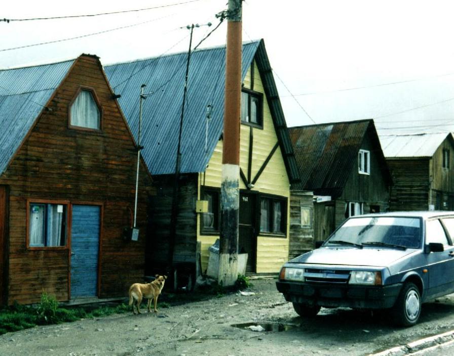 It's raining hard and the taxi works its way up the sloped
part of town where the newer houses are. Most streets are unpaved, curbs separate pot
holes from weeds and many houses are built in the traditional style of an A-frame-like
cottage. Dogs run free and don't seem to be owned.When I later pass on my bicycle, they
bark wildly and I am worried they might take a bite out of me.
It's raining hard and the taxi works its way up the sloped
part of town where the newer houses are. Most streets are unpaved, curbs separate pot
holes from weeds and many houses are built in the traditional style of an A-frame-like
cottage. Dogs run free and don't seem to be owned.When I later pass on my bicycle, they
bark wildly and I am worried they might take a bite out of me. They must be fed
by someone because there is hardly any garbage lying around that they could scavenge:
household refuse is placed out of reach in a wire basket atop a 5 ft pole in front of each
house. I had later asked whether one should be afraid of the dogs and the answer was a
laugh: you just throw a rock at them and they'll run. I had a chance to try it and it
works. For the rest of the trip, whenever I saw a dog down the road, I stopped the bike
and picked up a rock or two, just in case....
They must be fed
by someone because there is hardly any garbage lying around that they could scavenge:
household refuse is placed out of reach in a wire basket atop a 5 ft pole in front of each
house. I had later asked whether one should be afraid of the dogs and the answer was a
laugh: you just throw a rock at them and they'll run. I had a chance to try it and it
works. For the rest of the trip, whenever I saw a dog down the road, I stopped the bike
and picked up a rock or two, just in case....
Ushuaia started out as a prison colony and has always been subsidized by the government
in Buenos Aires: Ushuaia is strategically important to secure Argentina's claim to the
south.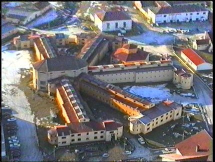 Only recently has it grown due to the large number of
visiting tourists. At the fairly new airport, several flights arrive each day, and a
steady stream of cruise ships is responsible for the majority of curious folks that look
for anything interesting along the immature main street. Ushuaia bills itself as the
southernmost city on the globe, a title that has been successfully wrested from Punta
Arenas and that is now being contested by Puerto Williams, a village about 50km to the
east across the Beagle Channel on Chilean territory. Chile is
eager to promote flights to Puerto Williams just as Argentina is eager to block access to
that place. You will find it's difficult to commute between the two places, but you might
get the cheapest flight into the south by going (from Chile, of course) to Puerto
Williams instead of Ushuaia.
Only recently has it grown due to the large number of
visiting tourists. At the fairly new airport, several flights arrive each day, and a
steady stream of cruise ships is responsible for the majority of curious folks that look
for anything interesting along the immature main street. Ushuaia bills itself as the
southernmost city on the globe, a title that has been successfully wrested from Punta
Arenas and that is now being contested by Puerto Williams, a village about 50km to the
east across the Beagle Channel on Chilean territory. Chile is
eager to promote flights to Puerto Williams just as Argentina is eager to block access to
that place. You will find it's difficult to commute between the two places, but you might
get the cheapest flight into the south by going (from Chile, of course) to Puerto
Williams instead of Ushuaia.
| Ushuaia(oosweye´ä) city (1980 pop. 11,029),
Tierra del Fuego Territory, S Argentina, a port on the Beagle Canal, on Ushuaia Bay.
Settled in the 1870s by English missionaries, it was taken over by Argentine naval forces
in 1884. Lumber, livestock, and fishing are important to the local economy. ________________________________________ The Canadian Encyclopedia Plus Copyright © 1996 by McClelland & Stewart Inc. The Columbia Encyclopedia, Fifth Edition Copyright © 1994, 1995 Columbia University Press. Licensed from and portions copyright © 1995 by INSO Corporation. All rights reserved. |
The folks at the hospedaje are friendly. For dinner, I get a lift down to a restaurant and have a lengthy chat with the owner there, with my host acting as a translator. I hear about a Canadian from Montreal who passed through on a bicycle, many years back. There is even a photo to prove it. And in the evening, I call Pegg' in Canada to let her know that I have arrived safely. The phone call is done from a phone centre, one of the many that you find in the south. It is a place where you tell them the number you want to call, they'll dial it for you and you talk in a private booth. Then you pay and the fee is substantial. The calls to Canada typically cost me around $20 for about 10 minutes. If you want to cut costs, ask whether there is a discount after some hour (e.g. 10 p.m.). Many people are employed in this business, and I have talked to several young folks that were taking training for this job. But it's a job that is easily automated and thus will disappear. These people will be looking for something else in a few years...
![]()
At the phone centre, I meet a Chilena from Punta Arenas. She calls home to her mom and later we chat over a cup of coffee. There is little work back home and she has a worker's permit that allows her to stay here, working in a small hotel. She tells me about the uncertainty of getting the annual renewal of her permit and that she'd rather work somewhere else if she knew of a place where she could go. But with little education, what chance will she have to apply for immigration elsewhere. I feel for her plight and am sorry I cannot help. We part and go our own ways. But as I trot "home" in the pouring rain, I realize I am a cheapskate for not sending her home in a cab: she's been coughing and is coming down with a cold. Here I am, 53 years old and have not learned the basics yet....
In the hospedaje there is a visitor from Germany. Anya had trekked across South America a few years ago, made friends and is back for two weeks of visiting. She is concerned about my inexperience with the country and gives advice: what food to buy and where to buy it, whether the water along the way will be drinkable ("only drink where there are forests"), telling me how to say things in Spanish and so on. Too bad that her time is already spoken for: it would be great to travel with her.
For breakfast, I cycle down to the main street to one of the many cafés. After having locked the bike to a lamp post, I enter the place and look around. Several locals sip their morning coffee and they are amused at something. I am bold enough to ask and the owner explains that I am the source of mirth: no one here locks their bikes. I am still learning, and this lesson will hold true for all of Patagonia: property is safe.
About 10 km west of Ushuaia is the National Park, starting on the Beagle
Canal and running north along the border with Chile into the interior of Tierra del Fuego.
Anya recommends a visit there, as this is a place encompasses the 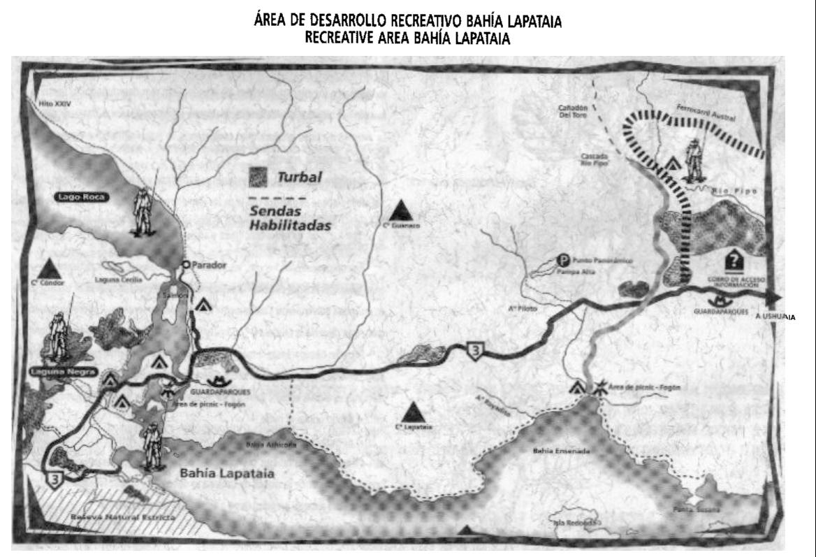 character of the
extreme south: sea, mountains, lakes, forests and moors.
character of the
extreme south: sea, mountains, lakes, forests and moors.
I decide to make this my trial run and pedal there on my bike, with rain pouring down as
usual. The paved road goes through the newer sections of the rapidly expanding town, and,
where the municipal garbage dump is, it changes into a dirt road.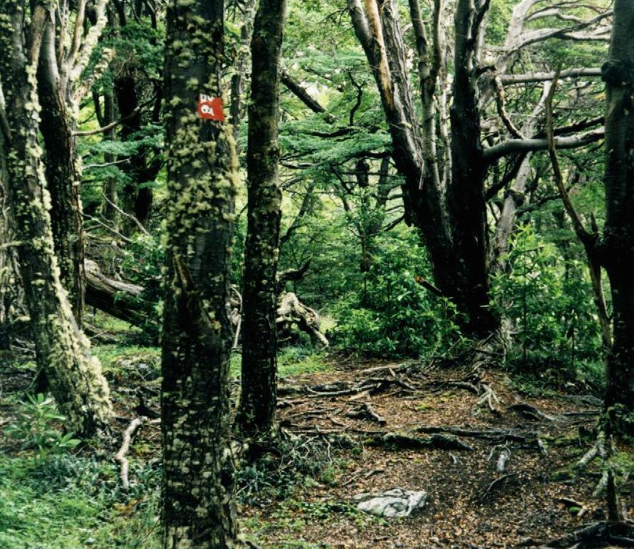 Crested Caracas,
carrion-eating eagles, circle overhead and screech. When I try to get up closer, a pack of
dogs comes into sight and I avoid a confrontation by heading back towards the park. The
road is not bad once you are inside the park, but the park is a popular tourist spot and
thus cars and buses pass frequently. Once at the gate, I pay my five pesos and the park
attendant hands me a sketchy map with a few trail options. I decide to head down to
the first parking lot at the water's edge (the place is marked on the map above with a
star and a camping symbol).
Crested Caracas,
carrion-eating eagles, circle overhead and screech. When I try to get up closer, a pack of
dogs comes into sight and I avoid a confrontation by heading back towards the park. The
road is not bad once you are inside the park, but the park is a popular tourist spot and
thus cars and buses pass frequently. Once at the gate, I pay my five pesos and the park
attendant hands me a sketchy map with a few trail options. I decide to head down to
the first parking lot at the water's edge (the place is marked on the map above with a
star and a camping symbol).
There, at the parking lot, tourists spill from a bus, crowd the grassy 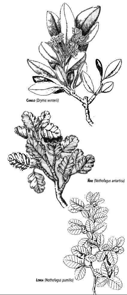 knoll to snap pictures and
then seem ready to move on.A handful of them ventures down to the water, and some even
across the little creek where lenga trees reach with their bizarre branches
knoll to snap pictures and
then seem ready to move on.A handful of them ventures down to the water, and some even
across the little creek where lenga trees reach with their bizarre branches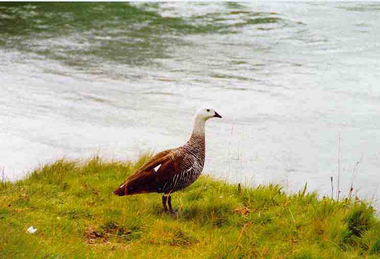 towards the bay and
strange orange sponge fungi litter the ground.
towards the bay and
strange orange sponge fungi litter the ground.
I chain the bike to a fence and start walking west, along the Beagle Canal for about 10 km. Sea weed is showing in the water near the shore, and shells litter the pebbly beaches, birds such as oyster catchers run over the rocks and geese and ducks paddle across the coves. The water is quiet near the shore, but further out I see the pattern of waves and know the wind is running free in the channel.When the trail leads away from the shore, there is a chance to take a closer look at the forest. Trees are stunted and trunks are short, branching wildly, not far above the ground.The forest lacks the grandeur and order of the northern forests of home, and I start to understand why people such as Darwin were so negative about the environment (and its human fauna) here. Later, I studied how the native Yamanas built their canoes: much cruder than their north-American counterparts. The materials locally available are not as suitable for boat building: there is no equivalent to birch bark and the brittle lenga bark must do; there are no pines with their magical resin and thus clay, moss, grass and an algae need to be employed to seal the seams; and the tricky water and wind conditions demand a deep boat. For details of these canoes, click here.
The trees are "Lenga" (Southern Beech), Ńire and I also recognize Calafate.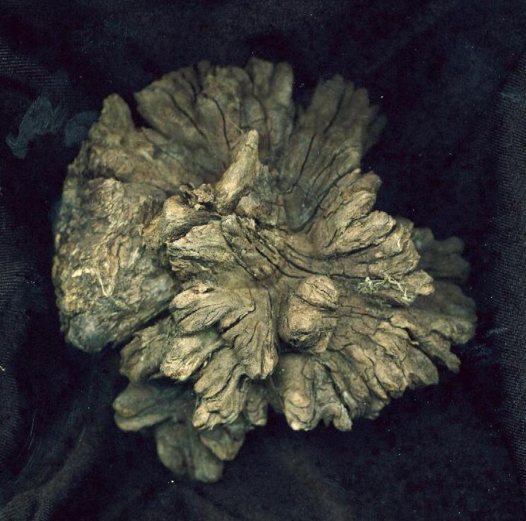 I try Calafate
berries, and they are quite edible, similar to blue berries. Later I realize that Calafate
berries are a lot sweeter in the country further north where they get more sun. As I make
my way up a slope, a strange "KRRRK!", followed by plaintive cries, makes me
look up in surprise and there is a pair of Caracaras 2 m above me in the trees. I think
back to Bruce Chatwin's "In Patagonia": it describes an event where a boat
capsized and the men were floating in the water. Soon they were attacked by birds like
these and eventually let themselves drown to escape the vicious bird attacks. I shake off
these horrible thoughts and move on. Many trees suffer from a cancer and weird burrs
develop on the branches. There is a picture of one, to the left. Later, I cross an area
flooded by beavers and understand the frustration of hikers who have to abandon the
original trail because of the newly created ponds. Those beavers were brought in from
Canada some decades ago and I am not sure I should be proud of the connection with my home
country. Back
in Canada, I welcome beavers on the trail since they ensure that even trickles of water
are canoeable. Here, they are a pest.
I try Calafate
berries, and they are quite edible, similar to blue berries. Later I realize that Calafate
berries are a lot sweeter in the country further north where they get more sun. As I make
my way up a slope, a strange "KRRRK!", followed by plaintive cries, makes me
look up in surprise and there is a pair of Caracaras 2 m above me in the trees. I think
back to Bruce Chatwin's "In Patagonia": it describes an event where a boat
capsized and the men were floating in the water. Soon they were attacked by birds like
these and eventually let themselves drown to escape the vicious bird attacks. I shake off
these horrible thoughts and move on. Many trees suffer from a cancer and weird burrs
develop on the branches. There is a picture of one, to the left. Later, I cross an area
flooded by beavers and understand the frustration of hikers who have to abandon the
original trail because of the newly created ponds. Those beavers were brought in from
Canada some decades ago and I am not sure I should be proud of the connection with my home
country. Back
in Canada, I welcome beavers on the trail since they ensure that even trickles of water
are canoeable. Here, they are a pest. 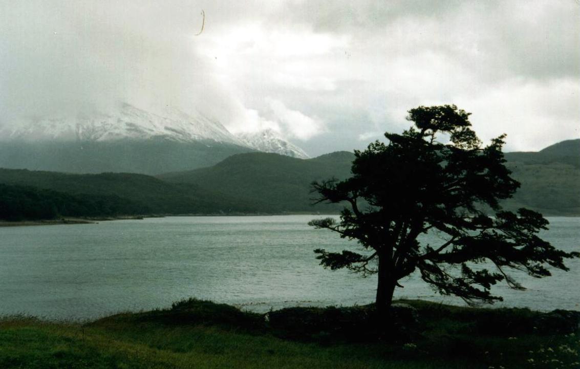
I walk back along the road towards where I left the bicycle. Buses and cars slow down as they pass me on the wet gravel, and I regret not having taken the same trail back along the shore, away from cars and gravel. Then, I cycle back towards Ushuaia, in the rain, but with the wind from behind. It's a lot easier than going the other way.
I am glad I made the excursion to the park: I understand a bit more about this place, and my gear seems OK for the ride ahead.
Forward to Puerto Natales
Back to Trip Overview
Back to Erhard's Home page